Thursday, July 30, 2009

Road Trip 2009 Day 7-8

I woke without a plan, yet I knew exactly what I was going to do. I had a shower, breakfast, the bike packed and was on the road by 8 A.M.

Day 7 may have gone a little different if my motel had had a guest laundry. I don't mind washing my clothes, but I just hate being stuck at a laundry mat for 2 hours. With that in mind I turned right out of the motel and headed east on U.S. 50. I had 3 destinations for the day, the ghost town of St Elmo, Pikes Peak and a place to lay my head when I got tired, anything in between would be a bonus.

You would think after traveling a few thousand miles (most in northern New Mexico and southern Colorado) I would have learned the local gas rule, "1/2 a tank or less? then stop at the next station you see", that would have been Poncho Springs, but not me I'm a "run it till your on fumes" kind of guy. After an extra 25 miles for gas I was on County Gravel Rd 162 heading for St Elmo.

St Elmo is a very well preserved ghost town. The reason? Because all of the people have driven the ghost away. St Elmo is privately owned so there is limited access to the buildings, viewing is basically from the road and boardwalk. I was still able to capture a few interesting images. There is another ghost town farther down the road, but that road is gated. More Private property.

Not long after leaving St Elmo I was heading east on U.S. 24, next stop Pikes Peak. Actually my next stop was a little shade along the road to eat left over pizza. When I arrive at the Pikes Peak toll booth I'm told it's $9 to enter, and I'm also told that the road is paved, gravel, paved and more gravel. In parting I'm told that I picked a good time to visit as the road is in excellent condition for the International in 4 days time. I would hate to see the road when it's in poor condition. I now have a new found respect for the drivers who compete in the Hill Climb, they either have some really big brass balls or a total lack of reality. The summit is shoulder to shoulder people. It doesn't take much time to see the sights and I'm on the way down.

It was late afternoon when I stop for gas in Colorado Springs. The plan then was to head towards home stopping for gas & food when needed, when I needed a rest I would look for a place to stay. I stopped for supper at Taco Johns in Goodland, KS after that I had no good reason to stay in Kansas. There would be no sleeping until I could sleep in my own bed.

I had watched the sun set in my mirrors as I approached Kansas and as I crossed Missouri I watched the sun rise. the last 100 miles were the hardest, I was ready to hit the hay. I'm a little gray on the exact time I arrived home, but I do remember figuring I had been on the road for 22 hours. A day later I figured the mileage as being 1048 per google. After a quick shower I was asleep before my head hit the pillow, not to fully awaken until the next morning.

See you on the road.
GAW

P.S. I will post a summary of the trip and some thoughts on what is to come. It shouldn't take to long, it just needs A/D conversion (it's all on paper). Check back soon.
Road Trip 2009 Highlights

Wednesday, July 29, 2009

Road Trip 2009 Day 6

Sorry for the delay, There was no time to update on the road and once I was back home I came down with a bad case of the lazy's. Better late than never, right?

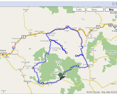
The map above shows me taking I-70 for part of the days ride, it is not accurate. When I drew the map Google didn't think I should ride over Independence Pass.

After Day 5 I wasn't about to rush into anything so I took my time getting ready. I had the free breakfast at the motel (better than most free breakfast, but worth more space) and was on U.S. 50 heading west just before 9A.M.

Not far from Gunnison I notice a large bird of prey (not sure is it was an eagle or hawk, sorry I'm not an Ornithologist) that looked like it was going to auger in nose first, and it did. Just as I approach the crash site the bird takes flight. It appeared the bird picked up an unwitting passenger. Today's in-flight meal will be chipmunk sashimi.

I take CO 92 and follow it along the Black Canyon of Gunnison, stopping to apply my rain gloves when the clouds let loose. Day six would be no different from the rest, rain on and off through out the day, sometimes very hard, others just a few drops. Not long after putting on my rain gloves I stopped to remove them at the overlook where Gunnison Creek meets the Gunnison River. With different gear (hiking boots) I might have hiked the trail to the bottom of the canyon, next time.

On to Hotchkiss and north on CO 133 through Paonia, home of "Top O the Rockies" BMW Rally, I was early by a few weeks. Over McClure Pass a meager 8755 feet. Just down the east of McClure Pass I stopped to shoot some photos of Hays Creek Falls and the Crystal River.

Next I followed CO 82 a 4 lane highway into Aspen. Aspen is packed with people and cars, I can only imagine what it must be like in Ski season. None to fast I'm east of Aspen heading for Independence Pass. Halfway between Aspen & Independence Pass I spot what turns out to be the abandoned Independence mine. I took a great deal of care parking the bike on its side stand just off the road on the beginnings of a jeep trail, all to no avail. Before hiking around the mine works I broke out the trail mix for a little energy boost, with a mouth full I got quite the surprise as the bike tried to take me out. Luckily as it fell the seat gave me a push out of the way. I said a few choice words as I picked it up. I didn't think to document the moment on film until the bike was up-right and in a more stable spot. I've had the bike for 13 years and until yesterday it had never been off its wheels, now twice in 2 days. Photos of the mine taken and on the road again I come to the mining camp not even a half mile down the road. There is a nice level parking lot (with lots of cars and people), but I don't stop. Cars and People don't fit into my ghost town photos.

At the summit of Independence Pass (12,065 feet) there is a over look at the end of a short hike, but again the parking lot is full, so I snap a shot of the Pass marker and skip the rest. When I reach U.S. 24 I decide to save the side trip to Leadville for my next trip west, It was getting late and I had a long way to my motel. I headed south to Buena Vista, fuel-up and follow County Rd 209 to Cottonwood Pass. Cottonwood Pass will shave 20-30 miles off my trip back to Gunnison but will require 16 miles of grave road going down the other side. At the summit (12,126 feet) I take a rest and a few photos. It's the highest point on my trip so far and the highest on two wheels for me. Cottonwood Pass is more to my liking, only a few people around when I get there and before I leave I'm the only one there. It's not that I don't like people, I just enjoy the quite solitude. The 16 miles of gravel wasn't bad, hard packed Dirt with just little loose stuff on top.

Even with the short cut it was still after 8 P.M. when I arrived back at the motel. By the time I decided I was to tired to walk to the Cowboy bistro and should order pizza the pizza joint had closed already. Luckily Mario's Pizzeria & Ristorante was open late and delivered. So I got another pizza and salad from there. I think the pizza was actually better this time. After dinner I made sure everything was organized and ready to go onto the bike in the morning, as I would be moving to an as yet unknown location in the morning.

See you on the road.
GAW

Road Trip 2009 Highlights

Friday, July 17, 2009

Coming Soon Day 6-8.

Just taking a vacation from the vacation. I have added some photos, just follow the link below. GAW


Road Trip 2009 Highlights

Sunday, July 12, 2009

Road Trip 2009 Day 5

I believe on a trip like this you have to have a day to test your fortitude to have fun. Today was that day.

1. The first gas stop of the day. You must pre-pay before you pump. They have one pump that takes CC's and 6 that don't. You have to leave your CC with the clerk along with the other six...NOT.

2. Breakfast wasn't terrible, not great either. The service was slow and forgetful.

3. Taking a gravel road, that in hind sight I shouldn't have, I had to stop for people standing in the middle of the road. The bike stopped for 1 nano second then took off backwards (very steep road). It finally stopped moving when it and I were only 12 inch's from tumbling 10ft into a fast running creek, and the bike was laying on it's side. I would have taken a photo of it laying there but the people I had to stop for were freaking out.

4. Not that long after putting the bike back on two wheels, the rain came, but this time it brought it's good friends Thunder, Lighting and Hail. Not terribly big but it still stung when it hit a soft part.

5. At 10,000 feet thunder is much louder, and scares the sh@t out of you, when you are putting on your rain gloves.

6. Falling out of your chair in your motel room still sucks, even though nobody else saw it.

7. The restaurant you want to eat at is closed on Sundays. But Supper at the back-up was very good, so not to bad a day.

See you on the road.
GAW

Road Trip 2009 Highlights

Saturday, July 11, 2009

Road Trip 2009 Day 4


I was a little confused with the time this morning and got a later than planned start, but my day would have been a much different had I left when planned.

First order of business was breakfast. I headed west on U.S. 160 out of Durango. Being this close to Mancos, I couldn't not go to Ted's Taco. The Frybread Breakfast sandwich with egg's, sausage, cheese, onions and of course green chile was excellent. You just can't go wrong with Ted's Taco.

While eating I met Colin a fellow BMW rider from New Mexico. He was having Tires installed on his GS at Basin Motorcycle Works, just across the street from Ted's. I followed Colin to Basin Motorcycle Works to see if they might have a speedo cable for my bike. Not only did they have the proper cable they had the bike in the service bay replacing it in no time.

From Mancos I went in search if ghost towns. There were a couple places along CO 145, That I was looking for, but they were either not ghost towns (people living there) or it was raining to hard to get the cameras out. Ophir looked like the best place for photos but it was raining quite hard there. In fact it rained on me just about the whole time I was on CO145. I did see a biker down on the road, one of the few dry parts, no telling what happened, the bike was laying on it's side and police and ems were around the rider and passenger, I hope in the end they were able to walk away with only minor injuries.

I took CO 62 to Ridgeway and then head south on U.S. 550. Ouray just shows up out of nowhere, and if you didn't see the small specks moving back and forth on the canyon wall, you would think it was a dead end. 550 is just one switchback after another as it climbs the mountain out of Ouray.

Not long after leaving Ouray I zipped past a very small sign pointing to Ironton, I caught a glimpse of something and made a U-turn and saw the sign. It's amazing to see the buildings just sitting there. I only took photos and left only foot prints.

Leaving Ironton, U.S. 550 climbed Red Mountain pass then dropped down into Silverton. Continuing south I went over Molas pass and Coal Bank pass. U.S. 550 continues to go back and forth until you are about 30 miles from Durango then it straitens out, the temperature also rises as you drop below 7500 feet.

Any photo's I might post from this loop can not do the real thing justice. The roads are great motorcycle roads, but they do have a lot of traffic, and the highway department doesn't know what guardrails are. Looking over the edge of the road can give you a bad case of vertigo if you aren't careful. I look forward to riding it again, but maybe with out all the rain.

After getting back to the motel I wiped some of the stink off and took the bus to Serious Texas BAR-B-Q and following Colin's advice ordered the Texas Taco, a flour tortilla filled with beef brisket, onions, jalapenos, and cheesy fried potato's. I also got the Buttermilk lemon pie. I went to bed very full and happy.

See you on the road.
GAW

Road Trip 2009 Highlights

Friday, July 10, 2009

Road Trip 2009 Day 3

Today was a low mileage day. I started my day with left over green chile pizza for breakfast. I still needed my caffeine fix so I had a large Iced Mocha espresso while I waited for the first train of the day to depart Chama. I followed the train(see the photo and video) over Cumbres pass along with a small army of cars and trucks, all stopping at each photo op along the way.

After chasing the train I returned to Chama with the intention of getting a Burrito from Feliciano's (the pizza joint) and gassing up the bike, but Chama was without power and the town was closed, as in everybody locked up shop and went home at noon. I had enough gas to get to Pagosa Springs, CO. I guess I will have to return if I want to talk to Frank again and get that burrito.

I gassed up in Pagosa Springs and 4 miles west on U.S. 160 my speedo stopped working, I think everybody ask about my bike may have brought me some bad luck ( I always tell them it's 13 years old and runs great), hopefully the speedo will be my only mechanical problem...

The traffic in Pagosa Springs and Durango was quite heavy and being at only 6000 feet it was getting hot. I was spoiled with Chama's 8000 foot elevation. Over the last few days I have noticed that the temperature has a nice change someplace between 7500 and 8000 feet, anything above 8 is great.

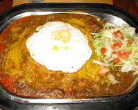
I made it to the motel about 3 p.m. and took a break and ate some trail mix for lunch (missing that burrito). The motel is several miles from downtown, but there is a free trolley (this is a tourist town). About 5 p.m. I caught the trolley to find some supper, And find it I did. I was looking at Francisco's menu and when I saw the Enchiladas Rancheros I knew what I was having and where I was going to eat, but I did continue down the street in a halfhearted effort to see what else there was. Enchiladas Rancheros: One beef and two cheese stacked enchiladas smothered in green chili and Crowned with an egg cooked to order. You know what I say: Everything is better with a Fried egg...

Tomorrow: a Ghost Town or bust...

See you on the road.
GAW

Road Trip 2009 Highlights

Cimarron Canyon State Park.


I couldn't go to bed until This was done. This is a video of U.S. 64 as it climbs through Cimarron Canyon State Park between Cimarron & Eagle Nest, NM. On my first trip through the park I caught up to one truck pulling a trailer and he pulled over at the first possible place to let me by. Once I had the camera all set, I couldn't get a break, so stopped a couple of times to let the cars clear out of my way. You may notice a few cuts. I also muted the sound from most of the video, as I shot this with a Canon G9 digital camera and the wind noise is just to much for it's small microphone. Enjoy.

See you on the Road.
GAW

Thursday, July 9, 2009

Road Trip 2009 Day 2

Today was sensory overload. I have so many vinaigrette's banging around in my head I'm dizzy...

1. Breakfast at Copper kitchen in La Junta, CO. Breakfast Burrito to die for. Conversations with the locals.
2. U.S. 350 with the mountains so close yet so far.
3. Raton Pass, the first pass of the day. 7834 ft.
4. Coalfax, NM and the slowly fading wooden passenger car and box car.
5. Cimarron Canyon State Park.
6. U.S. 64 between Tres Piedras and Tierra Amarilla, NM. 11,000 feet, no traffic in my way, two wheel bliss...
7. The double Rainbow.
8. Going 185 miles on ONE tank of gas. The last time I went that far on a tank of gas I had to walk to the gas station.
9. Pizza with Green Chile in it!
10. Getting a ride back to the motel with Frank the owner of Feliciano's Home Run Pizza. He wouldn't let me walk the 2 blocks in the rain.

Though I only traveled just over 400 miles today my brain is truly about to explode. If I were to come home tomorrow my trip would have been a complete success.

Friday will be a low milage day, My plan is to photograph the Cumbres & Toltec. I will then head to Durango, CO a short distance northwest and call it a day.

Click on the image below to see photographic highlights of my Roadtrip.

See you on the road.
GAW

Road Trip 2009 Highlights

Wednesday, July 8, 2009

Road Trip 2009 Day 1


The Road Trip has begun. Today was pretty uneventful. I left home about an hour later than I planned. The first packing of the motorcycle always takes a while.

By the numbers:

3500 feet elevation increase.
720 miles by GPS.
11 1/2 hours on the road.
5 gas stops.
3 states, Missouri, Kansas and Colorado
1 Kansas driving award!

Today's plan was to get across Kansas, and I did. Tomorrow will start the good roads and food. Today i just had junk food, nothing worth photographing. At about 7:30pm someplace east of Dodge City I crested a hill going about 73 mph (posted 65mph) and was facing a Kansas State Trooper. In the end he was very nice and only gave me a written warning. As for driving awards go... not to bad.

See you on the road.

GAW


Road Trip 2009 Highlights